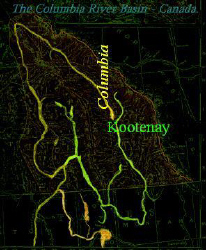
The word 'Kootenay' has become the modern name for a geographical area of South Eastern British Columbia, Canada that is within the Columbia River Basin system.
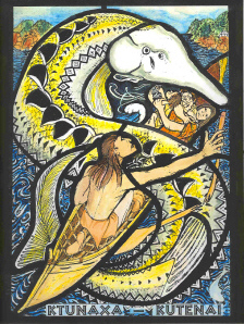
The word 'Kootenay' is derived from the intepreted name of the Ktunaha, an indigenous tribe of aboriginals. The remaining present-day tribes, prefer to be referred to as the 'Ktunaxa', their ancestral name.
In the past there were many more different tribal and band names, (than there are in usage today), that made subtle reference to the geographical location, ancient origin or sub-tribal relationships. Ktunaha, Ktunaxa, sometimes Kitunaqua or Kotounaha were pronounced many different ways depending on the ethnic origin of the speaker.
It is not difficult therefore to conjure up many a fur trader of Scottish descent shouting "Heere kemme thay wee Cottnehaws, teh trayde." This and other phonetic spellings of Ktunaxa appeared as geographical reference points (there were no place names) on the early maps of the Hudson's Bay Company. As early as 1792 Peter Fidler recorded his meetings with the 'Cotton-na-haws' and the North West Company's Alexander Mackenzie placed the 'Cottonahews' (and other spellings) on his early maps and in notes. When the Ktunaha first made it across the divide to trade at the fur posts in Alberta, the land west of the divide (B.C.) became referred to as 'the land of the Kutenais' by the many french-speaking fur traders and trappers. The French spelling 'Kutenai' is still preferred by many today, especially south of the border.
 When David Thompson was sent over the divide by the North West Company to trade with the Kootenais in the early 1800's, he preferred a phonetic Gaelic/Scottish spelling, referring to the 'Land of the Kootenaes' in his journals.
David Thompson was the first Mapmaker to use the word 'Kootenae' as a geographic reference when he first mistakenly referred to today's Columbia River as 'The Kootenae' on his charts. Today's Kootenay River was known as the 'Arc Plats' River by the French fur traders and explorers, after the unique 'Flat Bows' used by the tribe of Kutenais that roamed the river valley. Thompson called today's Kootenay River, 'McGillivray's River after his NWC colleagues.
After the Columbia River had been fully explored from it's source in Canada down through the present day United States, the 'Flat Bow River' was changed to 'Kootenay River', in honour of the aboriginal tribe.
The Canadian 'Kootenay River' after crossing the border, becomes the 'Kootenai River' in the United States of America.
White man's historic events including, explorations, mapmaking, trading, establishing territories and borders, encouragement of imported settlers, exploitation of resources, and continual changes of political policies, all played a hand in drastically re-shaping the ancestral world of the 'Ktunaha' into the modern situation with still unresolved issues from the past.
Each historic event has led to re-classification of tribal origins, relationships and re-definition of ancestral boundaries. After the border between Canada and the United States was implimented in 1846, aboriginals were forced to make choices of nationality, a concept totally alien to their world.
In Canada, the borders between the Provinces of Alberta and British Columbia were established along the great divide, in the late 19th Century. The Ktunaha that roamed across the divide the length of the Rocky Mountain Trench from 'Kootenay Plains' in Alberta, their summer hunting grounds, ( placed on the map by David Thompson ), down to the buffalo hunting grounds in present day Montana.
There are many instances on record of the Ktunaha regularly roaming as far as the eastern Alberta boundary and south as far as Wyoming in the USA. Indeed for many years 'Kootenay Lake', and 'Kootenay Pass' in the Waterton area of Alberta, were named in their honour, and entered on maps by the fabled 'Kootenai Brown' the mountain man/guide/Indian-fighter/Policeman of the late 19th Century.
Travels by Aboriginals in the pre-reserve, whiteman's settlement era, were only restricted by their understanding the limits of resouces available, achieving their intended destination for collecting food, or going to war with neighbouring tribes who were encroaching on their territories. In regards to the latter, territorial boundaries were always in a state of flexibility, as enemies asserted themselves, or retreated. In the 'Ktunaha' case this was usually the Blackfoot Confederacy.
British Columbia became a province in 1871. Later in the century after the discovery of ores and precious metals in the south eastern corner of the province, the Kootenay area had a great influx of explorers and opportunists. Towns and Cities mushroomed around the discoveries. The water-ways, the life-blood of the aboriginals were utilised for their transportation and electrical generation potential.
The aboriginals in the south-eastern corner of the province, were discouraged from staying in their traditional roaming grounds. The region now referred to as the 'Kootenays' was not just a vital area for the 'Ktunaha' but also for many other tribes who also travelled the rivers of the Columbia Basin.
The greater tribal groups were re-classified into smaller units, renaming them using geographic areas of where they happened to be at the given moment of classification. There were 'Upper Kutenai', 'Middle Kutenai, and 'Lower Kutenai' bands classified in accordance with the location on the 'Kootenay River' where they camped.This made it somewhat administratively easier later, to encourage them to settle down in these areas, and live a 'reserved' life.
Similar classification and actions were applied to the numerous other tribes, often renaming them, giving them 'whiteman's' imposed names for their rivers and land. Ironically David Thompson having had a tributary of the Fraser River named for him, now has a tribe that bears his name- The Thompson Band of Salish, their own name for the River is 'Ceqtamux', and the their own name for themselves,' Ntlakyapamuk'.
One linguist of high repute, J. W. Powell, who pioneered the classification of Aboriginal Languages, in 1891, went one step further in classification and tribal identification by adding 'an' to every collective name for the North American aboriginal tribes, resulting in the Ktunaha, Ktunaxa, now classified as speaking 'Kitunahan'.
Well-meaning researchers,ethnologists, sociologists over the years have studied many of the different aboriginal tribes, often applying the generic term 'Kootenay Indians' collectively to all the Aboriginals that have resided in the Columbia Basin of British Columbia.
The Federal Government of Canada, went even further, classifying all the Aboriginals across the nation under the homogenized grand title of 'First Nations'. This may imply that there is some recognition as historically being the first indigenous population of 'Canada'. But it does not give the 'First Nations' equal rights or autonomy. Being under the direct control of The Federal Government's Department of Indian Affairs means that their every request has to be filtered through all members of parliament and is subject to parliamentary approval.
However, when it comes to settling unresolved land claims, 'First Nations' have to negotiate directly with the Provincial Governments who also own the mineral rights to the land.
Unlike Alberta, who settled many treaty issues and formed reservations for their resident aboriginals, British Columbian aboriginals were left without treaty agreements and the many tribes and bands have had an uphill battle to settle their ancestral land claims and gain dignified solutions to unresolved issues.
Reference: The Uncharted Nations.Vol 111. Robert MacDonald. Ballantrae Foundation. Columbia Journals. Edited by Barbara Belyea. University of Washington Press.